Riverton Combo & Acreage
Range/Pastureland
Irrigated Cropland
Non-Irrigated Cropland
Residential
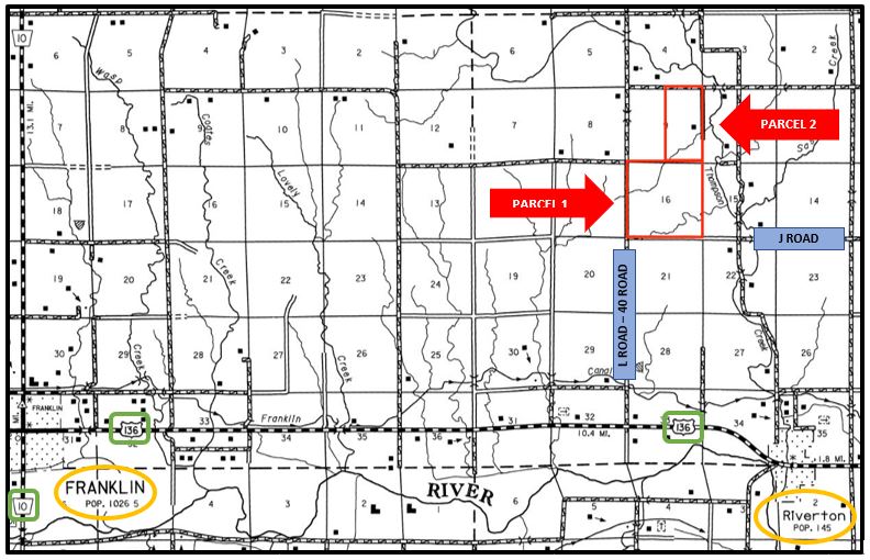
2 miles west and 2 ½ miles north of Riverton, Nebraska, northeast of the intersection of 40 Road and J Road in southeastern Franklin County, Nebraska.
Parcel 1: All of Section Sixteen (16), Township Two (2) North, Range Thirteen (13) West of the 6th P.M., Franklin County, Nebraska [645.48 tax-assessed acres].
Parcel 2: The East part of Section Nine (9), Township Two (2) North, Range Thirteen (13) West of the 6th P.M., Franklin County, Nebraska [315.93 tax-assessed acres].
All of Parcel 1 and the S1/2 SE1/4 of Parcel 2; SOLD at $940,000.00
Tract of land in the N1/2 of the SE1/4 and part of the NE1/4 of Parcel 2; SOLD at $205,000.00
Tract of land in part of the NE1/4 of Parcel 2; SOLD at $350,000.00
Lower Republican Natural Resource District
Well Registration: G-172516
Completion Date: 5/22/2014
Well Depth: 180 feet
Static Water Level: 103 feet
Pumping Level: 107 feet
Column: 1.25 inches
Gallons/Minute: 6 gpm
Solar powered stock water pump with auto-fill tank float system and tanks.
Total Farmland: 311.02 acres
Total Cropland: 103.53 acres
Government Base Acres: Corn - 69.73; Wheat - 25.11; Grain Sorghum - 2.76
PLC Yields: Corn - 147; Wheat - 49; Grain Sorghum - 82
*Note these figures were estimated due to farm division.
This farm is located in the Lower Republican Natural Resource District, and is subject to pumping restrictions. It contains 85.6 certified irrigated acres.
Well Registration: G-094505
Completion Date: 11/26/1997
Well Depth: 55 feet
Static Water Level: 0 feet
Pumping Level: 1 feet
Column: 9 inches
Gallons/Minute: 12 gpm
*Well was reconditioned when pivot was installed.
Submersible stock well with auto-fill tank float system and tank. Other stock tanks filled with artesian well water with jet pump/pressure tank supplying pressure.
Well Registration: G-056175
Completion Date: 4/14/1977
Well Depth: 178 feet
Static Water Level: 20 feet
Pumping Level: 59 feet
Column: 9 inches
Gallons/Minute: 1200 gpm
Pump: Westor Land Roller
Gearhead: Amarillo 60hp
Pivot: 2013 T-L
Power Unit: 3054 Cat Diesel with tank
Total Farmland: 311.02 acres
Total Cropland: 103.53 acres
Government Base Acres: Corn - 69.73; Wheat - 25.11; Grain Sorghum - 2.76
PLC Yields: Corn - 147; Wheat - 49; Grain Sorghum - 82
*Note these figures were estimated due to farm division.
Subject to a lease for the 2019 crop/grazing year, expiring on February 29, 2020.
1,276 sq. ft. well-kept one story residence with basement
3 bedrooms, 2 bathrooms
Barn with 2 Lean To's and cattle corrals
Steel Bin, with Drying 15' - 29' dia.
Other good outbuildings along with a separate set of corrals with alley way & semi loading chute.